Roads
Out of
Kabul
we were blessed with about 25 miles of good road, the best I’ve seen yet over
here. The road was about three lanes wide -- one in each direction with a
suicide lane in the middle -- though without painted lines anywhere. No reflective markers or guard rails, either. But it
was paved in recent years, and without potholes or washouts. In America, it would have been an unfinished
country road. In Afghanistan, it was a turnpike.
At
the time of this writing, the
most recent and reliable statistics I could find on roads throughout the world
came from the 2003 CIA World FactBook.
Comparing
Afghanistan
with another Third World country,
Thailand, and a First World country, France, shows:
Size, sq km
Afghanistan
: 647,500
Thailand
: 511,770
France
: 545,630
Paved roads, km
Afghanistan
: 2793
Thailand
: 62,985
France
: 894,000
In other words, for every one mile of paved road in
Afghanistan, Thailand
has about 22, France
about 320.
Afghanistan
has a long way to go, and doesn’t even have the roads to get there.
I saw the importance of roads on our second day, when we
drove from Gardez to Zurmat.
The map shows it as a secondary road, typical of most
roads in the country. Like all secondary roads in
Afghanistan, and unlike secondary roads in America, it was unpaved. You drive on packed dirt and gravel, avoiding if possible the
rolling washouts created by rains and trucks. Most of the hour-plus drive was
made in second gear.
Afghanistan
is working on a “ring” road that will circle the country to tie its four
major cities together:
Kabul
to 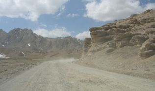 Kandahar
to
Herat
to Mazar-e-Sharif to Kabul. It’s as if America's only interstate ran from
New York
to
Atlanta
to
Los Angeles
to
Seattle
to New York, and virtually all other roads in the country were unpaved.
Kandahar
to
Herat
to Mazar-e-Sharif to Kabul. It’s as if America's only interstate ran from
New York
to
Atlanta
to
Los Angeles
to
Seattle
to New York, and virtually all other roads in the country were unpaved.
We
passed a number of graveyards along the way. The gravestones are a flat sliver
of rock a foot or two high, coming to a point at the top. Often a long stripped
branch stands above the grave, with a pennant, usually green or red, sometimes
black or white, fluttering in the breeze. None of the graveyards we saw was
large, most the size of a small back yard.
A number of areas along the road had crews in blue
uniforms and face masks clearing mines. Their work was marked by single stones
or small piles of stones painted white to indicate a removed mine. (Red paint is
for mines found but not yet removed; I didn’t see any of these.) Where one
mine was located, more were sure to be found, often in the dozens if not
hundreds, a step or two from each other.
Update, 1 May 2011, NY Times,
on building the road between Gardez and Khost.
Update, 10 February 2012, Wall Street Journal:
Roads to Nowhere.
next: On to Gardez
or back to Kohn's Corner