Approaching
Gardez
About two hours after leaving Kabul, we reached the mountain pass to Gardez.
South and east of Gardez was the area
of Operation Anaconda in early 2002, near where Osama bin Laden was believed to
be hiding. For more on this: http://www.globalsecurity.org/military/world/afghanistan/shahi-khot.htm
At 5900 feet, Kabul’s elevation is quite high enough, thank you, but Gardez is almost
2000 feet
higher. Getting to Gardez requires an hour-long climb up an ear-popping
2-lane, pot-holed road of serpentine switchbacks to reach a pass at 9600 feet. (The famous
Khyber Pass, just a couple hundred miles away, is at only 3500 feet.)
Views from the pass to the valleys below are spectacular
(and fatal for those who tumble off the unmarked, unlit, no-barrier road), but
we couldn’t stop for photos due to the danger of mines and insurgents.
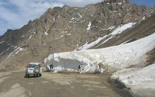 Near the
top of the pass we saw what was left of an avalanche that had put 15 feet of snow on
the road until it was finally cleared by American and Afghan military. Gardez was cut off from the world. Nothing got in, most
desperately neither
food nor fuel, in the middle of a bitter winter.
Near the
top of the pass we saw what was left of an avalanche that had put 15 feet of snow on
the road until it was finally cleared by American and Afghan military. Gardez was cut off from the world. Nothing got in, most
desperately neither
food nor fuel, in the middle of a bitter winter.
After cresting the pass, it’s back down 2000 feet to
reach Gardez’s 7500-foot elevation.
next: DDR
or back to Kohn's Corner